September 28, 2017 10:00 EST
Books, Maps & Manuscripts


121
(American Maps) 1 Vol. [Clark, Matthew; Carleton, Osgood; Boston Marine Society]. [Charts of the Coast of America from Cape Breton to the Entrance of the Gulph of Mexico]. [Boston] : [Published and Sold by Matthew Clark], [1789-1790]. Folio, 26 1/2" x 17 1/2"; 665mm x 440mm. [1], 16pp charts on 8 sheets. Retains one (1) of two original subscriber's (or contemporary) front boards.
A note on date of publication and title:
While fifteen of Clark's eighteen charts were issued with no date of imprint, three of them did bear the date of 1789, printed in the plate; these are Charts No. 6, No. 7, and No. 8., all of which are present in the copy at hand and attest to this. Evans, moreover, deemed the date of publication to be 1789, basing this fact on the external witness of "an advertisement." Other secondary sources have, however, long observed a notice printed in the Boston Gazette of 5 July, 1790, which lists the Charts as among those "Just Published," adding "(Price Thirty-six Shillings) / And to be Sold by Matthew Clark, and by Osgood Carleton, in his School near / Oliver's Dock, (where he continues to teach Navigation, &c, and procures / Books and Charts for Seamen on the lowest Terms) / A Complete Chart of the Coast of America, from Cape Breton into the Gulf of Mexico-upon a large Scale-neatly bound. Subscribers will be waited upon with their Books." It is on the basis of this source that the date of 1790 has become the accepted one, along with the title of the work, since Clark et al seem to have advertised it as such. A range over the two years seems to be the most compelling explanation, especially since Clark undoubtedly published his Charts as periodicals. (For a very limited preliminary discussion of these points, see Evans 21738; Shipton & Mooney; A List of the Geographical Atlases in the Library of Congress, Volume 3, Phillips & Le Gear, Washington, 1914; Wheat & Brun).
Remarks on form, content, and general condition:
Since its purchase and/or compilation (more on the latter point below), this atlas seems to have persisted only between temporary boards. It lacks the back board but retains the front, and an original spine cover in brown calf is present but cracked and highly distressed. The board which does abide is scuffed and rubbed and dusty, with its corners bumped. A mid 20th-century reader, in a moment of misguided inspiration, fashioned a 3" x 4" typewritten label on paper and affixed this at center with Scotch tape; it reads "Maps of Navigation of Coast of America…1789…Date appears on map of Cape Cod [i.e. Chart 9]at end of book…."
The front board is detached from the greater block, which itself remains presumably bound as it was originally sewn. There are is a fragment of "electrician's tape" and vestiges of three strips of (early 20th-century?) scotch tape on the board (all having left 1" x 1" blemishes), and three of the same on the past-down below. All of these betray several early readers' amateurish attempts at ad hoc re-bindings.
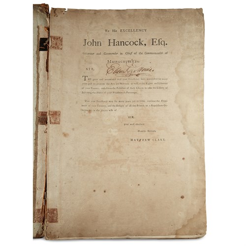
There is no general title-page, but it is extremely unlikely that it ever had one, as proven by comparison with all other exempla rediscovered to date (see e.g. institutional holdings NYPLS and Boston Athenaeum, OCLC 41995482; University of Michigan William Clements Library OCLC 79896302; LC unk81038873; &c). It does have its original prefatory leaf, with dedication to John Hancock recto, and with general certificate verso. This first leaf is browned recto-verso, damp-stained at inner lower margin, and there are three vestigial tape-trails opposite those on the paste-down described just above.
Neither Matthew Clark nor Osgood Carleton, Clark's mathematical authority for the putative exactitude of the Charts, personally signed this preface; this absence, along with the fact that Carleton did, however, sign each sheet, indicates straightaway that this copy is the result of subscription, rather than a one-time purchase. (See Wheat & Brun, passim).
The subscriber-owner, in this instance, appears to be a certain "Elihu Morris", who floridly inscribed his name in brown ink under the word "Massachusetts" at preface recto. He may be identified with many others known by this name in earlier periods, but a provisional identification might be made with the E. Morris specified in the will of William Morris of Shrewsbury, Monmouth County, NJ, dated 7 April, 1777 (and reprinted in various NJ state-historical compendia, many of which are readily available online).
This particular copy of Clark's Complete Set of Charts is comprised of sixteen (16) nautical charts, all of them numbered in the plate (with expected exception of No. 16, and the printer's error of Chart No. 15 misidentified as No.16). They are bound in reverse order, commencing with Chart No. 18 and concluding with Chart No. 3. This inversion of numerical sequence, which traces a south- northwards marine passage, adheres to the form and presentation of all other known copies of a complete Clark atlas, whether they were the result of subscription, or were one-time purchases.
All of the charts show depths based on soundings. None of them offer any scale, per se, though this has been reconstructed in both amateur and academic scholarship.
All of the charts in this example are pasted together two-by-two, constituting eight sheets of maps, a phenomenon likewise typical among the few other extant Clark atlases; various folds amid various sheets appear to be original. Sheets are typically full, but margins and borders overlap in many instances. There is some significant toning and browning, and there are a few closed tears, but there is no appreciable loss to margins and little to none inside the borders.
Specifics condition reports for specific charts, including dimensions, will be proffered gladly. Those dimensions below are purposefully sketchy, owing to the complexities of sheet-fold overlapping, and to the incredible delicacy of the sheets themselves and the care with which they must be handled.
The sequence of charts extant is as follows:
(Chart No. 18) CHART / OF THE / COAST OF AMERICA / THROUGH THE / GULPH OF FLORIDA / TO THE ENTRANCE OF THE / GULPH OF MEXICO. BOSTON PUBLISHED / AND SOLD BY MATTHEW CLARK. [1790]. 24 ½" x 16 ½" (See Wheat & Brun 627)
(Chart No. 17) CHART / OF THE / COAST OF AMERICA / THRO' THE GULPH / OF / FLORIDA. BOSTON PUBLISHED / AND SOLD BY MATTHEW CLARK. [1790]. Inscribed by Osgood Carleton. 23" x 16 ¼" (See Wheat & Brun 626)
(Chart No. 16) CHART / OF THE / COAST OF AMERICA / FROM THE / ND OF ST AUGUSTIN / TO / AYES INLET. BOSTON PUBLISHED / AND SOLD BY MATTHEW CLARK. [1790]. Inscribed by Osgood Carleton. 22" x 17 7/8" (See Wheat & Brun 625)
(Chart No. 15) CHART / OF THE / COAST OF AMERICA / FROM / ST HELENS SOUND / ST JOHNS RIVER. BOSTON PUBLISHED / AND SOLD BY MATTHEW CLARK. [1790]. Inscribed by Osgood Carleton. 25" x 16" (See Wheat & Brun 609)
(Chart No. 14) CHART / OF / THE COAST OF AMERICA / FROM / CAPE FEAR TO HELENS / SOUND. BOSTON / PUBLISHED & SOLD BY MATTHEW CLARK. [1790]. Inscribed by Osgood Carleton. 22 1/4" x 15" (See Wheat & Brun 598)
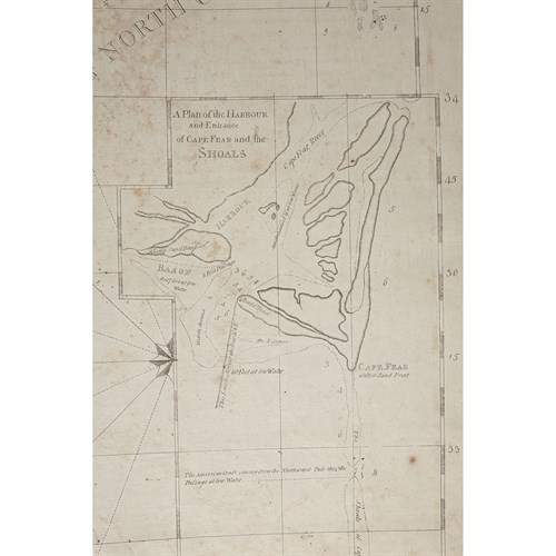
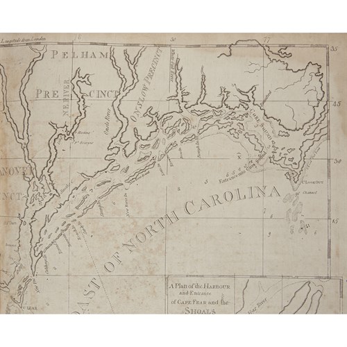
(Chart No. 13) CHART OF THE COAST / OF AMERICA FROM CAPE / FEAR TO CAPE LOOK OUT. FROM THE LATEST SURVEYS. BOSTON PUBLISHED / AND SOLD BY MATTHEW CLARK. [1790]. Inscribed by Osgood Carleton. 24 ½" x 16 ½" (See Wheat & Brun 577)
(Chart No. 12) CHART OF THE COAST OF AMERICA / FROM / ALBERMARLE SOUND / TO CAPE LOOKOUT. BOSTON / PUBLISHED & SOLD BY MATTHEW CLARK. [1790]. Inscribed by Osgood Carleton. 22 ½" x 17 ¼" (See Wheat & Brun 576)
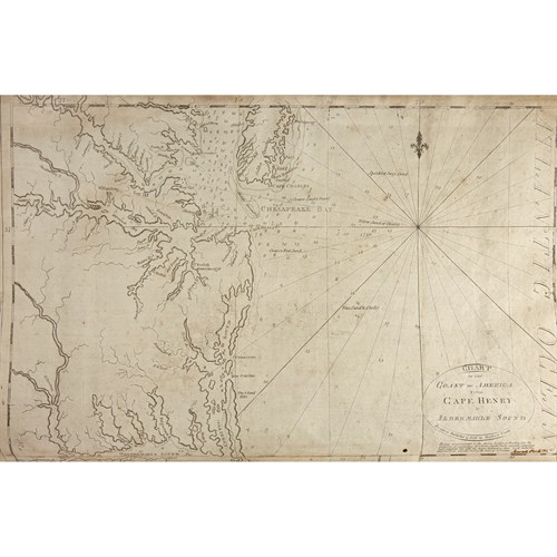
(Chart No. 11) CHART / OF THE COAST OF AMERICA / FROM / CAPE HENRY TO / ALBERMARLE SOUND. BOSTON / PUBLISHED & SOLD BY MATTHEW CLARK. [1790]. Inscribed by Osgood Carleton. 24 ½" x 16 ¼" (See Wheat & Brun 567).
(Chart No. 10) CHART / OF THE COAST OF AMERICA / FROM / CAPE MAY / TO / MASHAPUNGO. BOSTON / PUBLISHED & SOLD BY MATTHEW CLARK. [1790]. Inscribed by Osgood Carleton. 23 ¼" x 16" (See Wheat & Brun 306)
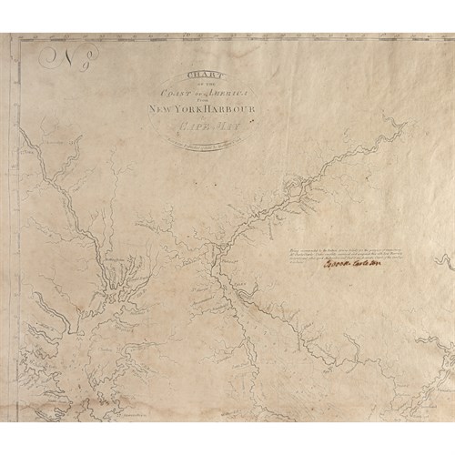
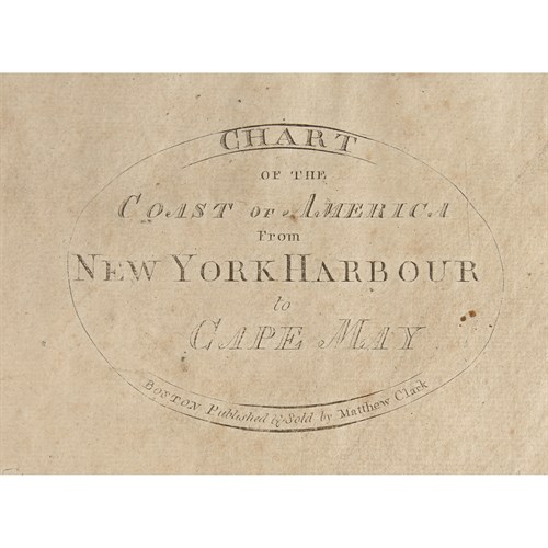
(Chart No. 9) CHART / OF THE COAST OF AMERICA / FROM / NEW YORK HARBOUR / TO /CAPE MAY. BOSTON / PUBLISHED & SOLD BY MATTHEW CLARK. [1790] 24" x 17" (See Wheat & Brun 307)
(Chart No. 8) CHART / OF THE COAST OF AMERICA / FROM / NEW YORK / TO / RHODE ISLAND / FROM THE LATEST SURVEYS. J. NORMAN SC / PRINTED FOR & SOLD BY MATTHEW CLARK BOSTON OCTR 1789. Inscribed by Osgood Carleton. 22" X 17" (Wheat & Brun 330)
(Chart NO. 7) CHART / OF THE COAST OF AMERICA / FROM / GEORGE'S BANK TO RHODE ISLAND / INCLUDING / NANTUCKET SHOALS, &C / FROM THE LATEST SURVEYS. J. NORMAN SC / PRINTED FOR & SOLD BY MATTHEW CLARK BOSTON OCTR 1789. Inscribed by Osgood Carleton. 24 3/8" X 16 ¾" (See Wheat & Brun 207)
(Chart NO.6) CHART / OF THE COAST OF AMERICA / FROM / CAPE COD / TO /CAPE ELIZABETH / FROM THE LATEST SURVEYS. PRINTED FOR & SOLD BY MATTHEW CLARK. BOSTON OCTR 1789. Inscribed by Osgood Carleton. 24 ¾" X 16 ½" (See Wheat & Brun 206)
(Chart NO. 5) CHART / OF THE COAST OF AMERICA / FROM C. ELIZ / TO MOUSE HARBOUR FROM THE LATEST SURVEYS. BOSTON / PUBLISHED & SOLD BY MATTHEW CLARK / JOSH H. SEYMOUR SCULP. [1790] Inscribed by Osgood Carleton. 25" X 16 ½" (See Wheat & Brun 165)
(Chart NO. 4) CHART / OF THE COAST OF AMERICA / FROM MOUSE HARBOUR. TO MAHONE BAY. (And below FROM THE LATEST SURVEYS. PUBLISHED & SOLD BY MATTHEW CLARK. [1790]. Inscribed by Osgood Carleton. 24 ¾" X 17" (See Wheat & Brun 95)
(Chart NO. 3) CHART / OF THE / COAST OF AMERICA / FROM / CAPE FORCHU TO LIVERPOOL / FROM THE LATEST SURVEYS. BOSTON / PUBLISHED & SOLD BY MATTHEW CLARK. [1790]. Inscribed by Osgood Carleton. 25" x 16 (See Wheat & Brun 93)
Charts absent from those sets deemed complete:
(Chart NO. 2) AMERICA / FROM CHARLOTTE BAY TO FORT HOWE / FROM THE LATEST SURVEYS. BOSTON / PUBLISHED & SOLD BY MATTHEW CLARK. [1790]
(Chart NO. 1) CHART / OF THE COAST OF AMERICA / FROM PORT HOWE TO C. BRETON / FROM THE LATEST SURVEYS. BOSTON / PUBLISHED & SOLD BY MATTHEW CLARK. [1790]
Provenance: From a Private Collection, from which it has never strayed, according to reliable inherited and/or living memory, since ca. 1880.
Sold for $212,500
Estimated at $150,000 - $250,000
(American Maps) 1 Vol. [Clark, Matthew; Carleton, Osgood; Boston Marine Society]. [Charts of the Coast of America from Cape Breton to the Entrance of the Gulph of Mexico]. [Boston] : [Published and Sold by Matthew Clark], [1789-1790]. Folio, 26 1/2" x 17 1/2"; 665mm x 440mm. [1], 16pp charts on 8 sheets. Retains one (1) of two original subscriber's (or contemporary) front boards.
A note on date of publication and title:
While fifteen of Clark's eighteen charts were issued with no date of imprint, three of them did bear the date of 1789, printed in the plate; these are Charts No. 6, No. 7, and No. 8., all of which are present in the copy at hand and attest to this. Evans, moreover, deemed the date of publication to be 1789, basing this fact on the external witness of "an advertisement." Other secondary sources have, however, long observed a notice printed in the Boston Gazette of 5 July, 1790, which lists the Charts as among those "Just Published," adding "(Price Thirty-six Shillings) / And to be Sold by Matthew Clark, and by Osgood Carleton, in his School near / Oliver's Dock, (where he continues to teach Navigation, &c, and procures / Books and Charts for Seamen on the lowest Terms) / A Complete Chart of the Coast of America, from Cape Breton into the Gulf of Mexico-upon a large Scale-neatly bound. Subscribers will be waited upon with their Books." It is on the basis of this source that the date of 1790 has become the accepted one, along with the title of the work, since Clark et al seem to have advertised it as such. A range over the two years seems to be the most compelling explanation, especially since Clark undoubtedly published his Charts as periodicals. (For a very limited preliminary discussion of these points, see Evans 21738; Shipton & Mooney; A List of the Geographical Atlases in the Library of Congress, Volume 3, Phillips & Le Gear, Washington, 1914; Wheat & Brun).
Remarks on form, content, and general condition:
Since its purchase and/or compilation (more on the latter point below), this atlas seems to have persisted only between temporary boards. It lacks the back board but retains the front, and an original spine cover in brown calf is present but cracked and highly distressed. The board which does abide is scuffed and rubbed and dusty, with its corners bumped. A mid 20th-century reader, in a moment of misguided inspiration, fashioned a 3" x 4" typewritten label on paper and affixed this at center with Scotch tape; it reads "Maps of Navigation of Coast of America…1789…Date appears on map of Cape Cod [i.e. Chart 9]at end of book…."
The front board is detached from the greater block, which itself remains presumably bound as it was originally sewn. There are is a fragment of "electrician's tape" and vestiges of three strips of (early 20th-century?) scotch tape on the board (all having left 1" x 1" blemishes), and three of the same on the past-down below. All of these betray several early readers' amateurish attempts at ad hoc re-bindings.
There is no general title-page, but it is extremely unlikely that it ever had one, as proven by comparison with all other exempla rediscovered to date (see e.g. institutional holdings NYPLS and Boston Athenaeum, OCLC 41995482; University of Michigan William Clements Library OCLC 79896302; LC unk81038873; &c). It does have its original prefatory leaf, with dedication to John Hancock recto, and with general certificate verso. This first leaf is browned recto-verso, damp-stained at inner lower margin, and there are three vestigial tape-trails opposite those on the paste-down described just above.
Neither Matthew Clark nor Osgood Carleton, Clark's mathematical authority for the putative exactitude of the Charts, personally signed this preface; this absence, along with the fact that Carleton did, however, sign each sheet, indicates straightaway that this copy is the result of subscription, rather than a one-time purchase. (See Wheat & Brun, passim).
The subscriber-owner, in this instance, appears to be a certain "Elihu Morris", who floridly inscribed his name in brown ink under the word "Massachusetts" at preface recto. He may be identified with many others known by this name in earlier periods, but a provisional identification might be made with the E. Morris specified in the will of William Morris of Shrewsbury, Monmouth County, NJ, dated 7 April, 1777 (and reprinted in various NJ state-historical compendia, many of which are readily available online).
This particular copy of Clark's Complete Set of Charts is comprised of sixteen (16) nautical charts, all of them numbered in the plate (with expected exception of No. 16, and the printer's error of Chart No. 15 misidentified as No.16). They are bound in reverse order, commencing with Chart No. 18 and concluding with Chart No. 3. This inversion of numerical sequence, which traces a south- northwards marine passage, adheres to the form and presentation of all other known copies of a complete Clark atlas, whether they were the result of subscription, or were one-time purchases.
All of the charts show depths based on soundings. None of them offer any scale, per se, though this has been reconstructed in both amateur and academic scholarship.
All of the charts in this example are pasted together two-by-two, constituting eight sheets of maps, a phenomenon likewise typical among the few other extant Clark atlases; various folds amid various sheets appear to be original. Sheets are typically full, but margins and borders overlap in many instances. There is some significant toning and browning, and there are a few closed tears, but there is no appreciable loss to margins and little to none inside the borders.
Specifics condition reports for specific charts, including dimensions, will be proffered gladly. Those dimensions below are purposefully sketchy, owing to the complexities of sheet-fold overlapping, and to the incredible delicacy of the sheets themselves and the care with which they must be handled.
The sequence of charts extant is as follows:
(Chart No. 18) CHART / OF THE / COAST OF AMERICA / THROUGH THE / GULPH OF FLORIDA / TO THE ENTRANCE OF THE / GULPH OF MEXICO. BOSTON PUBLISHED / AND SOLD BY MATTHEW CLARK. [1790]. 24 ½" x 16 ½" (See Wheat & Brun 627)
(Chart No. 17) CHART / OF THE / COAST OF AMERICA / THRO' THE GULPH / OF / FLORIDA. BOSTON PUBLISHED / AND SOLD BY MATTHEW CLARK. [1790]. Inscribed by Osgood Carleton. 23" x 16 ¼" (See Wheat & Brun 626)
(Chart No. 16) CHART / OF THE / COAST OF AMERICA / FROM THE / ND OF ST AUGUSTIN / TO / AYES INLET. BOSTON PUBLISHED / AND SOLD BY MATTHEW CLARK. [1790]. Inscribed by Osgood Carleton. 22" x 17 7/8" (See Wheat & Brun 625)
(Chart No. 15) CHART / OF THE / COAST OF AMERICA / FROM / ST HELENS SOUND / ST JOHNS RIVER. BOSTON PUBLISHED / AND SOLD BY MATTHEW CLARK. [1790]. Inscribed by Osgood Carleton. 25" x 16" (See Wheat & Brun 609)
(Chart No. 14) CHART / OF / THE COAST OF AMERICA / FROM / CAPE FEAR TO HELENS / SOUND. BOSTON / PUBLISHED & SOLD BY MATTHEW CLARK. [1790]. Inscribed by Osgood Carleton. 22 1/4" x 15" (See Wheat & Brun 598)
(Chart No. 13) CHART OF THE COAST / OF AMERICA FROM CAPE / FEAR TO CAPE LOOK OUT. FROM THE LATEST SURVEYS. BOSTON PUBLISHED / AND SOLD BY MATTHEW CLARK. [1790]. Inscribed by Osgood Carleton. 24 ½" x 16 ½" (See Wheat & Brun 577)
(Chart No. 12) CHART OF THE COAST OF AMERICA / FROM / ALBERMARLE SOUND / TO CAPE LOOKOUT. BOSTON / PUBLISHED & SOLD BY MATTHEW CLARK. [1790]. Inscribed by Osgood Carleton. 22 ½" x 17 ¼" (See Wheat & Brun 576)
(Chart No. 11) CHART / OF THE COAST OF AMERICA / FROM / CAPE HENRY TO / ALBERMARLE SOUND. BOSTON / PUBLISHED & SOLD BY MATTHEW CLARK. [1790]. Inscribed by Osgood Carleton. 24 ½" x 16 ¼" (See Wheat & Brun 567).
(Chart No. 10) CHART / OF THE COAST OF AMERICA / FROM / CAPE MAY / TO / MASHAPUNGO. BOSTON / PUBLISHED & SOLD BY MATTHEW CLARK. [1790]. Inscribed by Osgood Carleton. 23 ¼" x 16" (See Wheat & Brun 306)
(Chart No. 9) CHART / OF THE COAST OF AMERICA / FROM / NEW YORK HARBOUR / TO /CAPE MAY. BOSTON / PUBLISHED & SOLD BY MATTHEW CLARK. [1790] 24" x 17" (See Wheat & Brun 307)
(Chart No. 8) CHART / OF THE COAST OF AMERICA / FROM / NEW YORK / TO / RHODE ISLAND / FROM THE LATEST SURVEYS. J. NORMAN SC / PRINTED FOR & SOLD BY MATTHEW CLARK BOSTON OCTR 1789. Inscribed by Osgood Carleton. 22" X 17" (Wheat & Brun 330)
(Chart NO. 7) CHART / OF THE COAST OF AMERICA / FROM / GEORGE'S BANK TO RHODE ISLAND / INCLUDING / NANTUCKET SHOALS, &C / FROM THE LATEST SURVEYS. J. NORMAN SC / PRINTED FOR & SOLD BY MATTHEW CLARK BOSTON OCTR 1789. Inscribed by Osgood Carleton. 24 3/8" X 16 ¾" (See Wheat & Brun 207)
(Chart NO.6) CHART / OF THE COAST OF AMERICA / FROM / CAPE COD / TO /CAPE ELIZABETH / FROM THE LATEST SURVEYS. PRINTED FOR & SOLD BY MATTHEW CLARK. BOSTON OCTR 1789. Inscribed by Osgood Carleton. 24 ¾" X 16 ½" (See Wheat & Brun 206)
(Chart NO. 5) CHART / OF THE COAST OF AMERICA / FROM C. ELIZ / TO MOUSE HARBOUR FROM THE LATEST SURVEYS. BOSTON / PUBLISHED & SOLD BY MATTHEW CLARK / JOSH H. SEYMOUR SCULP. [1790] Inscribed by Osgood Carleton. 25" X 16 ½" (See Wheat & Brun 165)
(Chart NO. 4) CHART / OF THE COAST OF AMERICA / FROM MOUSE HARBOUR. TO MAHONE BAY. (And below FROM THE LATEST SURVEYS. PUBLISHED & SOLD BY MATTHEW CLARK. [1790]. Inscribed by Osgood Carleton. 24 ¾" X 17" (See Wheat & Brun 95)
(Chart NO. 3) CHART / OF THE / COAST OF AMERICA / FROM / CAPE FORCHU TO LIVERPOOL / FROM THE LATEST SURVEYS. BOSTON / PUBLISHED & SOLD BY MATTHEW CLARK. [1790]. Inscribed by Osgood Carleton. 25" x 16 (See Wheat & Brun 93)
Charts absent from those sets deemed complete:
(Chart NO. 2) AMERICA / FROM CHARLOTTE BAY TO FORT HOWE / FROM THE LATEST SURVEYS. BOSTON / PUBLISHED & SOLD BY MATTHEW CLARK. [1790]
(Chart NO. 1) CHART / OF THE COAST OF AMERICA / FROM PORT HOWE TO C. BRETON / FROM THE LATEST SURVEYS. BOSTON / PUBLISHED & SOLD BY MATTHEW CLARK. [1790]
Provenance: From a Private Collection, from which it has never strayed, according to reliable inherited and/or living memory, since ca. 1880.

